Lube up them lungs and salve your butt. From the Chilcotin to the California border, here are five backcountry bikepacking epics sure to send ya packin’. By Clare Menzel.
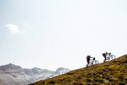
This story appeared in the Save The World? Issue as a sidebar to Andrew Findlay and Ryan Creary’s story called “Into The Superunknown” about bikepacking the Purcell Range. Feature photo above by Ryan Creary.
The BC Trail – 1,199 kilometres
This iconic route, which overlaps with the southwestern leg of Canada’s Great Trail, starts outside of Vancouver and ends in Fernie. Made up primarily of decommissioned rail trails, this route contains less singletrack than the other options, but it is no less demanding. Cutting across ranges and valleys while moving east along the province’s southern border, the aptly named BC Trail showcases the province’s diverse landscapes. You won’t struggle to find camping or regular food resupply points.
The Three Sisters/Three Rivers Route – 523 kilometres
Gabriel Amadeus and the Limberlost team (an Oregon-based bikepacking tour operator) spent years exploring central Oregon by bike and have developed a new route combining their favourite mountain-bike trails in the state. This singletrack-heavy trip, which opened in 2018, travels from Bend through remote national forest lands. You should have no trouble finding water, you will pass many waterfalls and springs, but food resupply points are quite spaced out. If you want a longer trip, singletrack spurs are aplenty.
The Oregon Timber Trail — 1,075 kilometres
This south-to-north traverse of Oregon connects the state’s premier singletrack. The southern 333-kilometre Fremont Tier, departing from the California border, is remote and dominated by singletrack. The 238-kilometre Willamette Tier follows the Middle Fork River through dark, green forests. The 181-kilometre Deschutes Tier, comprised of Bend-area mountain-bike trails, is the most accessible option for intermediate bikepackers. The northern 321-kilometre Hood Tier is punctuated with stiff climbs and rewarding views. Each segment poses different logistical challenges.
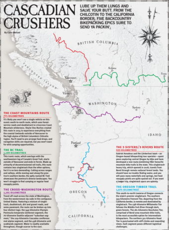
The Coast Mountains Route – 771 kilometres
It’s likely you won’t see a single vehicle on this scenic south-to-north route, which uses forest-service roads and doubletrack to crisscross Coast Mountain wilderness. Skyler Des Roches created this route in 2014 to experience everything from the coastal lowlands outside of Vancouver to the high alpine of British Columbia’s Chilcotin region. You’ll need to pre-arrange food drops and navigation skills are required, but you won’t want for wild camping opportunities.
The Cross-Washington (XWA) Route – 1,101 kilometres
Travel off-road across the entirety of Washington state from the westernmost zip code in the contiguous United States. Featuring a mixture of singletrack, doubletrack, dirt and gravel roads, and some pavement, the XWA can be broken up into four distinct legs: the 349-kilometre Olympic Peninsula temperate rainforest segment, the 76-kilometre Seattle-adjacent “suburban segment,” the 229-kilometre Cascades coniferous and alpine segment, and the 438-kilometre arid scablands segment. Water is readily available throughout, though scarcer to the east.
Related Stories
The West Coast Sees Significant Dumpage
Over the last 24 hours, many BC ski resorts have been reporting significant accumulations over this last heavy…
Framed in Leavenworth With Coast Mountain Culture
This past weekend, CMC was on hand to sponsor and participate in Leavenworth's Framed Photographer Invitational, where…
Sunshine Coast Enduro Brought the Heat
PRESS RELEASE: Wow what a weekend. It's fully a biker's heaven over there on the SSC. The goal of this race was to get…